Rockefeller center/the Rock, Centralpark, Ground Zero/Memorial, , fly to San Francisco
ROCKEFELLER
Olimme katselleet kaulat kenossa niin paljon pilvenpiirtäjiä, että oli aika katsella välillä alaspäinkin New Yorkia. Empire State Building olisi tietenkin ollut kiehtova paikka siihen tarkoitukseen, mutta otimme monista neuvoista vaarin ja päätimme kokeilla kuullun mukaan hieman edullisempaa ja tosin kai matalampaakin Rockefeller-centeriä yleiskuvan saamiseksi New Yorkista. Lisäksi kuulemma tänne oli lyhyemmät jonot kuin Empire State Buildingiin. Lisäksi saimme viimemainitun nyt mukaan omiin kuviimme.
We had look so much up to the sky scripers with our necks bended, so that it was time to look down to New York for a while. We were recommended to choose Rockefeller Center for this purpose, stead for Empire State Building, which is some higher of course, but Rockefeller is cheaper in ticketprices, and has shorter queues and we also get Empire State Building in our pictures.
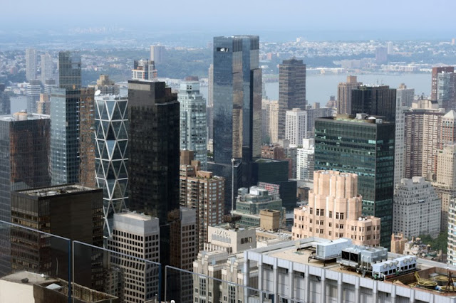
Empire State Building ja New York nähtynä Rockefellerin "The Rock" tornista. Valitettavasti meillä oli epäonnea hieman utuisen ilman suhteen. Kaukaisuudessa kuvan oikealla sivulla pienellä saarellaan erottuu himmeästi vapauden patsas. Alla seuraa kuvia eri suuntiin otettuina, mm. Keskuspuistoon.
Empire State Building and New York seen from Rockefeller/ The rock. We had bad luck with the some misty weather. On the right side, far away one can see on the little island the statue of Freedom. Under follows several photos to different directions, f.ex. Centralpark.Yllä yksi vain parista kuvasta, joissa olen onnistunut saamaan kadun tornin alapuolella näkyviin. Kuva on ylemmältä tasanteelta alemman tason yli ja kaukana alhaalla valkopukuisen tytön vieressä erottuu katu pikkuruisine autoineen.
Over one of the fjew pictures where I have managed to get a street visible . The photo is taken on the upper level of the tower and over the lower level, and far under on the left side of the girl with with dress one can see a street with the tiny tiny cars.
KESKUSPUISTO New Yorkin ja manhattanin sydämessä on yllättävän suuri, noin 4,2 km pitkä ja hieman yli 800 metriä leveä. Se sisältää myös paljon nähtävää ja koettavaa: se on suosittu lenkki/hölkkä- sekä pyöräilyalue, sekä asfaltoituja teitä ja luonnonmukaisia polkuja, siellä on suuria nurmikkoja piknikkejä ja alueita erilaisia pelejä varten, siellä on metsäalueita, mäkiä, tasankoja ja useita
Me aloitimme Keskuspuistoon tutustumisen hieman sen keskiviivaa pohjoisemmasta päästä, vastapäätä Guggenheimin museota ja noin keskivaiheilta suurempaa järveä, nimeltään Jaqueline Kennedy Onassis Reservoir (yläkuva). Etenimme sitten alaspäin keskikaupunkia kohden. Matkalla pysähdyimme katsomaan pientä ns. Shakespearen linnaa, kilpikonnia pienessä lammikossa (Turtle Bond), soutelemassa pienemmällä järvellä (The Lake), kävimme syömässä ihanan makoisen lounaan rantaravintolassa ja jatkoimme sitten kävellen edelleen matkaamme puiston eteläpäätä kohden. Tässä rivi kuvia puistosta.
CENTRALPARK in the heart of New York and Manhattan is surprisingly large, about 4,2 km land and a little over 800 meters bread. It has also lot of things to do and see: a popular area for all kind of training and excercise, cycling and walking, there is both asfalt ways and natural paths, large lawns for picnics and boll spils, wood and lakes, hills and flatlands, possibility for rowing, there is fountains and artmonuments, there is different happenings, concerts, you can watch animals or people, eat in restaurant or only take a cup of coffee - or you can only be there for yourself and calm down.
We started our tour there about from the middle of the park and went in vis a vis Guggenheim art museum, on the right side and middle of the Jaqueline Kennedy Onassis Reservoir (photo above). Then we walked down forward the middle of the city. We stopped and saw the little Shakespeare castle, looked at the small turtles on the Turtle Pond, we had a rowing tour on the on The Lake, we had a wonderful lunch in restaurant on shore, and walked again to the end of the park. Here some pictures from the park.
Tälläkin järvellä soudellessamme näimme kilpikonnia, tässä niitä kuusi kappaletta paistattelee päivää puunrungolla ja seitsemäs on uiden lähestymässä. Näimme myös sorsia, hanhia sekä valkoisia ankkoja (2 kuvaa ylöspäin) jotka ottivat kiven päällä päiväunia soutelijoista välittämättä.
Even on this lake, when rowing, we saw turtles, her six of them laing on the sunny stock and the seventh is narrowing swimming on left of them. We saw also different type of ducks swimming around and two white ones taking nap on a stone (two pix upper) not bothered of the rowboats.
**********
WORLD TRADE SENTER / MUISTOPAIKKA
Jatkoimme myöhemmin päivällä World Trade Centerin paikalle 11. syyskuun tapahtumien jälkeen rakennetulle muistopaikalle. Laitan tähän rivin kuvia ja tunnelmia sieltä, korkeista rakennuksista, osa valmiita, uusia tekeillä, turvallisuuskäsittelystä itse muistopaikalle mentäessä (- lähes yhtä tarkkaa kuin amerikkalaisessa maahantulotullissa!), plakaatista menehtyneiden palomiesten (yli 300) muistolle ja lopuksi itse itse tapahtumapaikalle rakennetuista vesiputouksista. Kaikki niin suurta, niin paljon ihmisiä, niin paljon nimiä ja niin monia kuolleita. Niin surullista.
WORLD TRADE SENTER / MEMORIAL
Later this day we went to see the Memorial place after Word Trade Center and 11th September.
I put here a row of pictures and imiges from there, the high houses ready and under construction,
the way and security to the area, the memorial plakate of the firefighters and to the end from the big waterfalls. It was so large, so many people, so many names of so many dead, so sad.
,
Osa kuolleiden palomiesten suuresta muistolaatasta, jossa nimet alla.
A small part of the big memorial plaque for the firefighters who died, with their names below.
Tämä matala lasirakennus toisen vesiputousaltaan päässä on kansallinen 11. Syyskuun Muistopaviljonki ja museo. Norjalainen arkkitehtifirma "Snøhetta" ("Lumihuppu") on ollut mukana rakennuksen suunnittelussa ja piirtämisessä.
This ¨low glassbuilding in the end of the one of waterfalls is the national 11th September Memorial Pavillion and museum. The Norwegian architectfirm "Snøhetta" ("Snowcap") has been with in the planning and drawing the building.

******
Kohden SAN FRANCISOA
Toward SAN FRANCISCO
Neljä päivää New Yorkissa, paljon nähty, ja vielä paljon enemmän nähtävää, mutta meidän oli aika kääntää ajatuksemme länteen ja kohden San Franciscoa. Meillä oli upea ilma New Yorkissa, tosi lämmin, aurinkoinen, mutta kostea. Lähtöpäivän aamupäivällä tuli kevyt sade, mutta pian olimme pilvien yläpuolella ja jälleen paistoi aurinko! Lähdimme New Yorkin Pen Stationilta junalla Newarkin lentokentälle, mistä lento lähti mukavasti alkuiltapäivästä ja olimme perillä sopivasti illallisen aikaan.
Four days in New York and have seen a lot, and still more to be seen, but it was our time to turn our thoughts to west and San Francisco. We had a wonderful weather all the time in New York, very warm, sunny but rather humid. On the morning of leaving it started to rain a little, but soon came we over the clouds and the sun was shining again. We took train from New York's Pen Station to Newwark Airport, where our flight started on a early afternoon, and we arrived in S.A. just fine
i dinner time.
Maanviljelyseutua keskimaassa. Osaako joku kertoa miksi suurimmaksi osaksi joka paikassa oli maa jaettu samankokoisiin suurempiin neliöihin, jotka sitten taas jaettu neljään osaan, joissa sitten useimmissa oli keskellä samankokoinen ympyrä nähtävästi viljeltyä aluetta? Miksei ole käytetty koko neliön aluetta, miksi ympyrät, ja miksi kaikki neliöt ja sen mukaan myös ympyrät käytännöllisesti katsoen joka paikassa täsmälleen yhtä suuria? En ole milloinkaan ennen nähnyt vastaavaa!
Farming areas in the middle country. Can someone tell me why almost everywhere the land was dealed to bigger isometric quadrates, then again these to four, and in almost every smaller quadrate have a circle which is probably farmed area? Why not use the hole quadrates, why only circles, and why all the quadrates and then also circles are practically of same size all over the farming areas? I have never seen this kind before!
Californian vuoristo alkaa! The Californian mountains begin!
Mitä tämä on, suola-altaitako San Franciscossa? En ole löytänyt vastausta!
What is this, salt basins in San Franciso? I haven't find the answer!
,,,and on the last moment land vanished under oss and we felt as we were going to land directly to the see! San Mateo Bridge just flashed under us, and then we were safely in San Francisco! You know where the pictures are from next time!
Bye bye,
Rosmariini


Ei kommentteja:
Lähetä kommentti